TALK sans papiers
During the Micronomics festival several artistic interventions will be presented on the Sans-Papiers issues in Brussels. In this public event, the artists give an audiovisual report on their actions in the 3 days of festival. The Sans-Papiers that participated in these projects will get a platform to share their experiences and interact with the public.
TALK sans papiers@ Micronomics Festival
sa-za 02/05/09 – 18:30 > 20:00 – free/gratis
Corner rue d’Alost & A.Dansaert – 1000 BXL – Belgium
With
– De Tafel Keuken – La Table Cuisine
– (R)apporter – portrait habit(er)
– Luistertoets – Test de compréhension orale
– Undocumented Trails
Undocumented Trails @ Micronomics festival
The Undocumented Trails project will be presented at the Brussels’ Micronomics Festival on Friday May 1st 2009 – International workers day – from 13:00 till 19:00. More information can be found here.
On Saturday 2/5/2009 at 18:30 Undocumented Trails will be part of the public discussion Talk Sans Papiers together with other projects, about how socio-artistic project can activate dialogues and more understanding between citizens and sans-papiers.
Undocumented Trails
The Undocumented Trails project will set up a marketplace where the public can ‘contract’ Sans Papiers workers through a simulated documentation procedure. This process seeks to exchange points of urban experience between the public and un-documented workers.
The work that will be traded is atypical: the workers need to walk every single street in a defined zone of Brussels with a GPS track logger. Upon the return from their trip, the GPS data is visualised and evaluated, so that at the end of the Micronomics festival the entire map of central Brussels will be colored meticulously. Walked routes are negotiated, traversing zones of mutual engagement – underscoring and stimulating a space for empowering working conditions. The streets and the visualized tracks become a testing ground to accentuate issues of documentation and migrancy, literally leaving a ‘paper trail’.
The absurdity of the work is a provocation that enlists everyone to activate and contribute to this collaborative and détourned micro-economy.
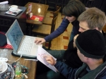
Undocumented Trails Visual Report
A visual report from the project iteration @ iMal.


Way points / Notes from the field
From the first iteration—Brussels Feb. 25-27, 2009
Thursday Febuary 26, 2009
ECOUTER> REGARDER>MARCHER
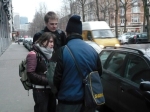
>> Meet 8:30 am. Two of us are late. We go to the streets of boulevard de Dixmude … also known as ‘cafe cigarette’ laden with many of workers taking breaks from the cold outside, others who are part of another network of work, telephone connections, word of mouth for “white” work the limbo of waiting on the street for a truck to pick them up. We listen, we trace, collect the delicate stories of migration: Tenerife | Guinea | Morocco. Routes traveled, pauses, cities of transition, and a mobile unknown. M. looks at a stray image on a folder spread out on the cafe table, it expresses to him the idea of the danger of travel, the passage, the fear associated with crossing … a necessary risk.
>> Laayoune >Las Palmas>Madrid >Lille >Paris> Bacău> Hollands Spoor > Brussels> the list goes on in no particular order… routes shift, time spent, etc.
>> Immigration trails, Spain, Romania, Morocco, the economic crisis accentuates this already established network.
>> 10 days there, 36 hours there… 3 months waiting for papers somewhere else. The in-between liminal zone.
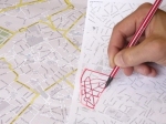
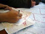
>> Determining zones, in which to divide the city. Is it by duration of the time passed in the walking these routes? Is it the kilometers needed to be traversed? We stare at the heart shape of the center of Brussels… the outlines, the figures, the main roads, and the points in which to make paths for our participants.
>> Dividing the zones in accordance to a pattern, to find a strategy to best allocate routes. We all sketch out our provisional maps on A3 paper. This labour –a day in the life of a day laborers also known as black work, under the table, illegal, sans papier, no worker’s rights, no work stability, time, pay, risk, police checks.
>>Like a painter who is hired to paint walls of a building, we propose a work situation whereby one paints or literally fills in the tracks of this city. Each participant or worker traces his or her movement street-by-street, sidewalk-to-sidewalk, crossing-to-crossing. In parallel each participant is wearing a GPS divide the trace the line as it communicates between the satellites hovering far above, and the signals the device emits from street level. These GPS tracks, transmitted from device to satellite: to be stored and retrieved in a digital file. Together with a paper map, with the physical traces drawn by the hand, whilst one walks, the legs transport this work.
>> Digital and Analogue, each has their purpose, another texture, another layer in which to retrace later.
>> Codes/ICONS: The drivers looking for workers use cards to express a YES or NO as to if work is available: a RED card means YES, we have work. a BLACK Card means NO, there is no work….
>>Economies: this is the tricky part, fixed price versus hourly…? Calculating the routes, kilometer, 5 kilometers per hour… is that a fast walking pace? How does one determine the speed, what is an average rate a specified zone? Or do we think of it like a farmer, the yield from the field. Who or how shall one determine or calculate a price a wage for such an absurd activity? Kilometers traveled or pre-determined zones in which to cover. How do we explain or articulate this work plan? Or we all negotiate the rates? Makes more sense to encourage a participatory environment with agency in which each person determines the price he or she is willing to work for. What is the criterion that we should look for? We realize that someone who has the ability to read maps is not necessarily something to take for granted. Can you teach someone to read a map in a short amount of time? How does someone orient themselves to the graphics of a map?
>> The circumference of the walking zones is even more difficult to decide upon. The time factor is also something we have to consider. Friday is the last day; we must put these maps, our decisions, and the mistakes into action.Do we evaluate their ‘work’ after we download the file from the GPS unit? We will see when certain roads have not been traversed. How do we account for this in a labor economy?
>> Documentation: We deliberate on the issue of transparency of our using cameras, voice-recorders, etc. We make it possible for anonymity, although in the end those we end up working with those who are comfortable with the presence of the media devices and the public visibility of the project.
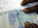
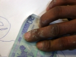
>> A picture of a hand a cup, a pencil mark, a coin with an almost imperceptible image of the Canary Islands, for example might say more than a face. Nouredine points to the 2 Euro coin, a 20 Euro bill, we strain our eyes to see the islands, a makeshift map, and a map that is familiar to him.
>> The Night Before. Mohammed calls we plan to meet at the tacky, smoke filled cafe on Boulevard de Dixmudelaan 8:45 am. We are going on trust that they will come to meet us tomorrow. We also are trusting that they will return our (or rather the workshops) GPS devices.
Friday February 28, 2009 (the last day)
We conduct ‘interviews’ – and set up our mobile ‘office’ in the café. The pricing of ‘zones’ goes through many negotiations with those who stop to talk to us.
To approach this as an economy the effort of a days work … how to optimize the walks. To cover all the streets without retracing, without extending extra effort, without doing double the work. This is not an easy task, even as we plot on paper in the safety of the workshop at IMAL, we try to predict how they might approach the streets, the map, the way they trace their lines on the written map.
The cafe owner tells us we must order something, or we cannot take up the tables… we order a round of Café au Laits. Our table is growing; the word of mouth from the street brings many to the cafe. We wait for Mohammed, Tayeb and Sorin to come back to the cafe and look at their GPS tracks. We are now part of this economy. Some in this collaboration are ambivalent about the process in such a short time span and to develop such complex themes seems overwhelming. This workshop project is only a scratching of a surface, a sketch a trace of the bigger issues that need time to be navigated, digested and formulated to open other notions of agency, labour and immigration issues. This is the first attempt to trace perhaps not only the workers GPS trails but the economy of the line: multiple, idiosyncratic, political, and always already incomplete.
POST SCRIPT #1
The analogy/balance has changed… and it is continuously changing… slowly these big cities are going to be ‘conquered’ by the ‘survivors’ of our society, by the millions of ‘ants’ supporting the system… and then what happens with the ‘bourgeoisie’? Are they all going to move away, to the countryside, to their little castles and green fields surrounding? Or will they accept to mix themselves with the other social classes, pretend being tolerant, and look the other way? I don’t know what is going to happen, but the gap between these two types of the ‘social order’ is big and is getting bigger and bigger… as these two extremes are getting richer and poorer… until one of these two extremes will have to give up their territory and leave… and I think we all have an idea who will surrender their city in the arms of ‘the others’… and then we will all be terrified by the results… watch out! Try to keep the balance…

leave a comment